Methods Projects
Sharing Fine Resolution Protected Health Information: Using Regionalization to Create HIPAA Compliant Aggregations (2020)
Presented as a contributive talk for AAG in Denver, CO.
Presented as a contributive talk for AAG in Denver, CO.
|
Click to download an R script that pre-processes shapefile input and calculates Ludovico Pinzari's Homogeneity Index (2018). Please note that this script contains Pinzari's script which is available for download here.
|
Promoting Knowledge of the Modifiable Areal Unit Problem in Public Health Research (2017)
Presented at GEOMED international, interdisciplinary conference on spatial statistics, geographical epidmeiology and geographical aspects of public health in Porto Portugal. For more on this project, click the link below.
Presented at GEOMED international, interdisciplinary conference on spatial statistics, geographical epidmeiology and geographical aspects of public health in Porto Portugal. For more on this project, click the link below.

|
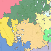
Heart Health Mapping: Delineating survey partitions for a cardiovascular disease prevention study (2015)
Presented at the International Esri User Conference in San Diego, CA.
The study below used ESRI’s Business Analyst Territory Design as a novel approach to partitioning study areas for community intervention research in the state of Minnesota. Territories were created by balancing a set of sociodemographic variables within MN so that 24 groups would emerge with at least 3 different clinic systems within them. These groups were essentially exchangeable in terms of the populations within them, and therefore they could be randomly assigned to the experimental conditions (Phase 1 & Phase 2 as represented by the maroon and gold groupings) and compared without great threat to the study's validity. Assigning experimental conditions to homogenous territories allows for more legitimate comparisons between territories. More research is warranted before promoting these methods as superior to conventional public health community intervention trials.
B. Krzyzanowski
